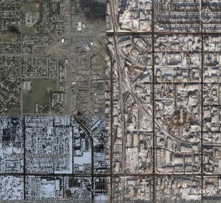
This concerned us on a number of fronts, and we have asked for a complete re-fly. Somewhere in Canada however, someone made a different call, and we ended up with something quite bizarre.

I'm presuming that the Northwest section of the photo is the more expensive part of town, and few people want to live in the cold 'South Side'. There's even a different climate on the East side of the city, so perhaps something for everyone in Edmonton!
For those of you running Google Earth, you can have a look yourself by downloading the location from here.
If you are not yet using Google Earth, I'd strongly advise you to check it out. Its basically an online globe, containing aerial photography of most of the planet, together with a community inputting to local content, so is a fascinating toy to play with. Best of all, its completely free. Get it here
Thanks to the excellent online publication The Register for pointing me in Edmunton's direction.
No comments:
Post a Comment